

By Marie Kennedy, The Mountain Times
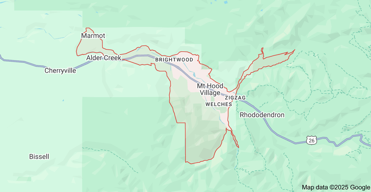
If you live in one of the communities between Rhododendron and parts of Cherryville, according to the federal government you live in Mount Hood Village. This is not to be confused with the Villages at Mt. Hood, which is a county thing. We have two very similar terms for this area, and it can be confusing: Mount Hood Village and the Villages at Mount Hood.
Mount Hood Village
The name Mount Hood Village comes from our national census. In order to better count residents in unincorporated communities, they create what is called a Census-Designated Place (CDP). Mount Hood Village is the CDP for the unincorporated towns in the Mount Hood corridor.
CDPs have been used in census counts going back to 1980, to allow for the gathering and tracking data from smaller unincorporated communities in the U.S. CDPs are not used for any legal purpose other than census information gathering.
Just a quick note about census taking, for the uninitiated. As outlined in the U.S. Constitution, every 10 years since 1790, the US Government has conducted a decennial census. We’ve had twenty-three Federal Censuses in all since then. Of course, they’ve changed in scope. Initially, they only counted the heads of household. That changed in 1850 when the census began collecting the names of all members of a household and included additional data in the results.
The Decennial Census of Population and Housing is designed to count every resident of the country and where they live on April 1, every ten years ending in zero. The census questionnaire collects information on race, ethnicity, migration, immigration, housing, health, education and other factors. House seats are determined by population, and budget planning and community projects depend upon the data that this census collects.
We’re about halfway to a new population census in 2030. Who knows what surprises we’ll see in the Mount Hood Villages’ profile. Other CDPs in Clackamas County include Beavercreek, Clackamas, Jennings Lodge, Oak Grove and Oatfield.
The Villages
at Mount Hood
The “Villages at Mount Hood” was created in 2006, when Mount Hood residents voted in favor of forming a village under the county’s Complete Communities ordinance part of the Hamlets and Villages program. Government Camp elected to do so at the same time.
The county ordinance allows for the formation of quasi-governmental entities in unincorporated areas, like the Mount Hood corridor, to allow rural residents to have more control over issues that directly affect them.
Initially, the local group was active, and by 2015 there were several projects planned, including bike and pedestrian paths and a Neighborhood Watch program. By 2016, sharp political divisions in the group led to the county dissolving the formal local committee.
Today we have an active Community Planning Organization, or CPO, that reviews and makes recommendations to the county on many local livability issues and land plan-ning. The former CPO was dissolved due to litigation issues over 10 years ago. David Lythgoe was instrumental in working with the county to revive the local planning organization, Hoodland CPO.
David explained, “[The CPO and the Villages] had two different missions. The villages were to advise the county and be a conduit from the community to the county on all issues.” Lythgoe continued, “The CPO deals strictly with planning issues at the county’s request. But lately we have gone beyond planning issues, informing the community on local issues, much like the Villages used to do.”
While the “Villages at Mount Hood” name remains in informal use, the county website shows no active villages currently, countywide, and just three active hamlets, which were confirmed by county staff. However, the Hoodland CPO is an active and engaging group, working with the county to help keep the community informed on key issues.
Next time we’ll cover the towns along Highway 26.