

By Steve Wilent, The Mountain Times
It’s painful to see that so many homes and businesses were burned by wildfires in the Los Angeles area in January. People killed — 27, so far — and injured. Lives, businesses, and livelihoods ruined or disrupted. But LA is far away and is so very different from our relatively remote mountain homes. What happened in LA couldn’t happen here, right?
Wrong.
The recent fires in the LA area were driven by very strong Santa Ana winds — with some gusts reportedly reaching 100 miles per hour. These are warm, dry winds from the east that are familiar to Angelenos — they happen every year, as do wildfires. Way back when I was a wildland firefighter in the Sierras in California, crew members sometimes made friendly bets on whether we’d be called to a fire in the LA area in the autumn. I never was deployed on such a fire, but I knew members of another crew that fought a fire over the Thanksgiving weekend and even had a turkey dinner instead of the usual fare.
This year the Santa Ana winds came later than usual and in the midst of a months-long period with very little rainfall (see tinyurl.com/2rnrzpb5). Grass, brush, and trees were bone-dry and ignited easily. So were houses, schools, churches, businesses and other buildings. More than 12,000 of them burned.
LA has seen destructive wildfires in the past. For example, in November 1961, the Bel Air- Brentwood Fire destroyed 484 homes and 21 other buildings.
We have such winds, too, now and then. They’re called East Winds here, and they occur when high-pressure weather systems to the east or northeast — over Montana, for example — blow wind toward low-pressure systems over the Pacific. These East winds can come at any time of the year. One winter a decade ago or so, a strong East wind blew down a large Douglas-fir tree on Lara’s and my property. It missed our house by 30 feet or so — a close call. I had my revenge bit by bit: I cut that tree into firewood and burned it over one winter in our wood stove.
East winds visit our area in the summer, too. I’m sure you remember the Riverside Fire in September 2020. Whipped by a strong East wind, a small fire along the Clackamas River exploded into a massive wildfire that burned 17 miles down the canyon in a single day, destroying dozens of structures and nearly engulfing Estacada. Imagine a wildfire starting near Welches and burning all the way to Sandy in a single day. It could happen.
Other wildfires in 2020 and in years gone by were driven by East winds. For example, the Tillamook Burn, a series of large wildfires in the Coast Range west of Portland between 1933 and 1951, burning a total of 355,000 acres (554 square miles), were influenced by East winds.
Why did so many homes in LA burn? Homes in suburban areas far from forests, chaparral, or other more-natural areas? A video from the New York Times offers some clues. The Times was granted permission to attach a camera to the nose of a Los Angeles County firefighting helicopter as it flew over areas burned by the Eaton Fire. The few minutes of video show swaths of burned homes, often in groups of a few or a few dozen, with nothing left but the foundations and charred debris. Around these ruins, some homes and other structures appear to be undamaged. Remarkably, although numerous trees were burned, there are far more green ones still standing, often near homes reduced to ashes.
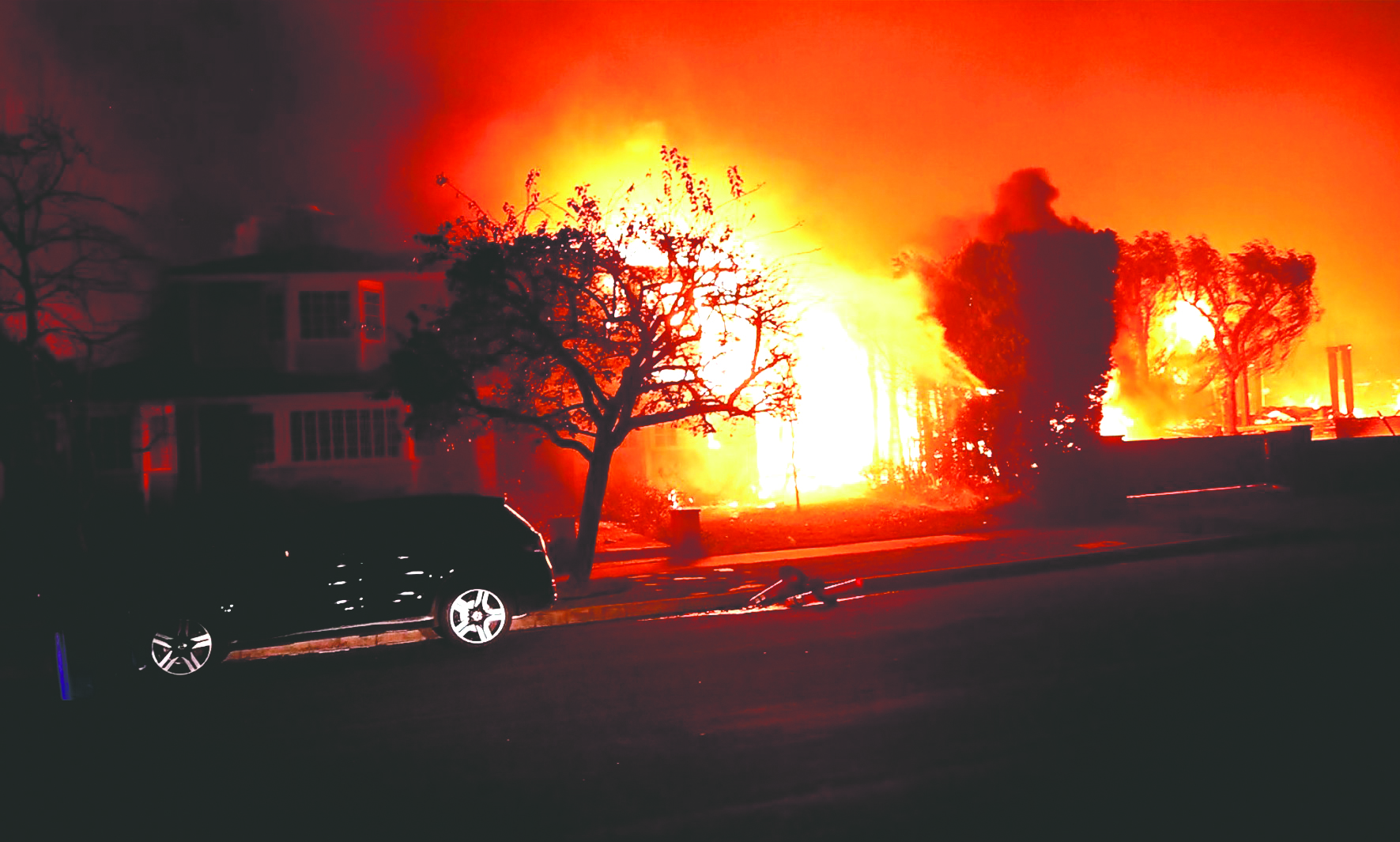
This wasn’t a forest fire, it was a house fire. That is, the fire burned from house to house: houses were the fire’s main fuel. The photo accompanying this article shows a scene from the Palisades Fire, where a house is beginning to burn as it is ignited by another house that is fully engulfed in flames. The flames and embers appear to be moving sideways, driven by a strong wind. I wouldn’t be surprised to learn that the fire continued marching from one house to the other down that street.
With a giant blowtorch like that, there’s little hope of saving homes a few feet apart. But what about groups of homes separated by wide asphalt avenues? How did the fire cross such barriers?
What flames couldn’t reach, flying embers did.
The same could happen here, in Timberline Rim, for example, or the neighborhoods around the golf course in Welches. Or anywhere in our area.
Houses in the path of a fire driven by an East wind won’t stand much of a chance. The best thing to do is to grab your “go bag” of valuables and essentials — you have one, right? — and evacuate.
What about houses not directly in the path of a raging wildfire? I’ve written before about how you can make your home or business more resilient to red-hot embers. Keep your gutters and roof clean, don’t store firewood next to buildings, remove flammable vegetation near your house, remove “ladder” fuels that can let fires move up into tree crowns, and so on. Hoodland Fire District’s web site has a wealth of information on creating a defensible space. Go to hoodlandfire.us, click on Prevention, Wildfire Information, and then on Creating Defensible Space. See also FireWise.org.
I’ve also written about AntFarm Youth Service’s Community Wildfire Defense Program (tinyurl.com/bdhbdfxw), which offers home wildfire hazard assessments and fuels-reduction treatments, often for free. AntFarm crews have been focusing on Timberline Rim as well as other areas. Oregon Public Broadcasting recently wrote about the program (tinyurl.com/y45ajah9).
I had intended to write about the State of Oregon’s wildfire hazard map (tinyurl.com/3ye4penv), which was finalized in January, and related regulations, but the LA fires made me shift topics. I’ll look at the wildfire hazard map next month.
Have a question about wildfire hazards or defensible space? When is the best time to create a defensible space around your home? Let me know. Email: SWilent@gmail.com.